
Free · Plan
When to go: seasons & closures
When to go, from the notes below (checked Oct 16, 2026; always re-check):
- May through September: do not hike midday. Summer temperatures around Las Vegas can be dangerous even early in the day.
- May 15–Sept 30: some Valley of Fire and Lake Mead trails close in summer heat. Check the park’s alerts before you go.
- October 1 through May 31: Red Rock Canyon’s Scenic Drive needs a timed-entry reservation for 8 a.m.–5 p.m. entry, made at recreation.gov.
- Mt. Charleston: trails climb well above the Las Vegas valley; cold, snow, ice and hypothermia are risks there.
- Any time it might rain: stay out of washes and slot canyons, and check the National Weather Service forecast (weather.gov/vef).
Read Before you go before you use this guide.
Free · Safety
Desert & mountain safety
Heat kills in the desert. Summer temperatures around Las Vegas can be dangerous even early in the day. Do not hike midday from May through September. Follow every heat advisory, heat closure and trail restriction issued by the managing agency (listed in this guide with the date we checked; always re-check). Carry more water than you think you need, plus salty snacks. There is usually no water on the trail, so do not count on any natural source. Start early, turn back when half your water is gone, and watch for signs of heat illness (headache, dizziness, nausea, confusion, stopping sweating). Heat illness is a medical emergency: call 911.
Summer closures: some Valley of Fire and Lake Mead trails close in summer heat (generally May 15–Sept 30), and Lake Mead can add closures on very hot days. Check the managing agency’s alerts before you go.
Flash floods. Do not enter washes, slot canyons or narrow drainages if rain is possible, even if the storm is miles away and the sky above you is clear. Water can arrive suddenly with debris. Never drive or walk through flowing water on roads or in washes. Check the National Weather Service forecast (weather.gov/vef) before you go.
Wildlife. Watch where you put your hands and feet; rattlesnakes are common in warm months. Do not approach, feed or touch any wildlife, including wild burros, horses and bighorn sheep. Feeding wildlife is harmful and may be prohibited by the managing agency. Keep pets leashed where required and away from wildlife. If stung or bitten, seek medical help immediately.
Closures, permits, fees and timed entry. Areas in this guide are managed by different agencies with different rules, fees, hours and permits, and these change. Example: Red Rock Canyon National Conservation Area (BLM) requires a timed-entry reservation for the Scenic Drive from October 1 through May 31 for 8 a.m.–5 p.m. entry (as published on BLM/Recreation.gov, checked Oct 16, 2026). Reservations are made at recreation.gov, not through us. Seasonal closures (for example, the summer closure at Gold Strike Hot Springs in Lake Mead NRA), fire restrictions, road closures and wildlife closures can apply at any time. Before every trip, check the official page linked in each area section. We list fees and rules as published on the date shown; we do not guarantee them, and you are responsible for obtaining any required pass, permit or reservation.
Maps: OVERVIEW ONLY. NOT FOR NAVIGATION. Maps in this guide are simplified locator maps. They are not to scale for route-finding, may omit hazards, junctions, closures and terrain, and must not be used for navigation. Carry an official map and a reliable navigation tool (GPS device or offline app with a charged battery and backup power), know how to use them, and stay on designated trails.
In an emergency, call 911. Cell coverage is spotty or absent on many trails, so do not count on it. Before you go: tell someone your exact plan (trailhead, route, expected return time) and when to call for help if you haven't checked in. Carry a charged phone, a backup battery, a headlamp, a whistle, a first-aid kit, sun protection and extra water. Consider a satellite messenger or a phone with satellite SOS for remote trails. If you are lost, stay put, stay visible, and conserve water and phone battery. If you have signal, call 911 and give your trail name and GPS coordinates.
Leave No Trace. Please follow the seven Leave No Trace principles: (1) Plan Ahead and Prepare; (2) Travel and Camp on Durable Surfaces; (3) Dispose of Waste Properly; (4) Leave What You Find; (5) Minimize Campfire Impacts; (6) Respect Wildlife; (7) Be Considerate of Other Visitors. Learn more at lnt.org/why/7-principles. Petroglyphs and cultural sites are irreplaceable: look, don't touch, and never carve, chalk or climb on them.
Kids, pets and groups. Adults are solely responsible for minors and pets in their care. Pet rules (leashes, trail restrictions, heat) are set by each agency. Follow the official rules linked in each area section. Pavement and rock get hot enough to burn paws. We don't judge which trails suit any particular child, pet or person.
Free · Start here
How to use this guide
Every trail here was checked against the managing agency's own page or PDF on Oct 16, 2026. If we couldn't confirm a detail from an official source, we left it off the card instead of guessing. Trails we couldn't confirm at all are left out.
Every trail card shows the date we last checked it against the managing agency's official page or OpenStreetMap. Older dates mean more chance something has changed. Details we couldn't confirm are left off, so check with the land agency before you go.
Map key: cyan solid line = trail open as of our check; magenta dashed line = seasonal closure or closed. Numbered pins mark the approximate trail start.
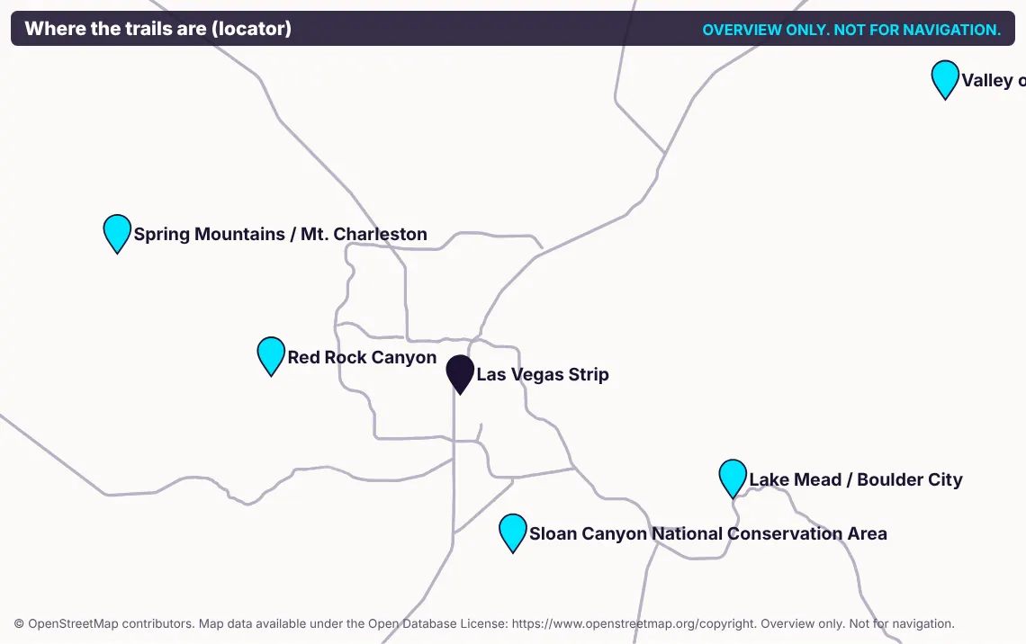
Overview only. Not for navigation. © OpenStreetMap contributors, ODbL: https://www.openstreetmap.org/copyright
Free · Read first
Before you go
BEFORE YOU GO: ASSUMPTION OF RISK. READ THIS FIRST.
Hiking, scrambling and outdoor recreation in the Mojave Desert and the Spring Mountains are inherently dangerous and can result in serious injury, permanent disability or death. Risks include, without limitation: extreme heat, heat exhaustion, heat stroke and dehydration; flash floods; lightning; cold, snow, ice and hypothermia (especially on Mt. Charleston); falls, loose rock, rockfall and exposure to cliffs; getting lost; wildlife, including rattlesnakes, scorpions, Africanized bees, mountain lions and wild burros or horses; poisonous or spiny plants; contaminated water; vehicle traffic at trailheads and on roads; inadequate cell coverage; delayed rescue; and the acts or omissions of other people. You are solely responsible for your own safety and decisions, and for those of anyone in your care, including children and pets. By using this guide you knowingly and voluntarily assume all risks, known and unknown, and, to the fullest extent permitted by law, you release Vegas Daily Drop from all claims for any injury, death, loss or damage arising from your use of this guide or your participation in any activity described in it, including claims based on our alleged negligence or on errors or omissions in this guide.
Hiking involves inherent risks including serious injury or death; you are solely responsible for your safety and decisions.
Limitation of liability. To the fullest extent permitted by law, Vegas Daily Drop is not liable for any injury, loss or damage arising from use of this guide. The Vegas Daily Drop Terms & disclaimer (linked at the bottom of every page) also apply.
Use at your own risk. Trail and weather conditions change, sometimes within minutes. This guide may be out of date the day you read it. Check official sources and posted signs before you go, and obey all closures, signs and ranger instructions. They override anything in this guide.
Distances, times and elevations are approximate. Figures are taken as published by the managing agency or derived from OpenStreetMap data, and are rounded. Your actual distance, time and effort will differ with route choice, conditions, fitness and weather. Do not plan water, daylight or turnaround times on these numbers alone. We do not guarantee their accuracy.
Independent publication. Vegas Daily Drop is an independent publisher. This guide is not affiliated with, endorsed by, sponsored by or approved by the National Park Service (NPS), the Bureau of Land Management (BLM), the U.S. Forest Service (USFS), Nevada Division of State Parks, Clark County, the City of Las Vegas, the City of Henderson, or any other government agency. Agency names are used only to identify who manages each area. For official information, use the agency links in each area section. No agency logos are used.
Important: please read before using this guide. This guide is published by Vegas Daily Drop for general informational and entertainment purposes only. It is not professional advice of any kind (legal, financial, investment, tax, medical, safety, travel or otherwise). Information was gathered from public sources and was believed accurate when checked, but prices, schedules, hours, routes, rules, closures and conditions change often and without notice. We make no warranties and do not guarantee accuracy, completeness or timeliness. Always confirm with the official source before you rely on anything here. You use this guide at your own risk. To the fullest extent permitted by law, Vegas Daily Drop is not liable for any loss, injury or damage arising from its use. Using this guide means you agree to the Vegas Daily Drop Terms & disclaimer (linked at the bottom of every page).
Fitness and medical caution. Hiking in heat, at altitude (Mt. Charleston trails climb well above the Las Vegas valley) or on steep terrain places serious stress on the body. Consult a physician before beginning any strenuous activity, especially if you are pregnant, have a heart, lung or other medical condition, or take medication affected by heat or exertion. Know your limits, turn back early, and never pressure anyone to continue. Nothing in this guide is medical or fitness advice, and no trail described here is suitable for everyone. Difficulty ratings are the managing agency's ratings, attributed, not ours.
Sponsors & affiliate links. This guide has no sponsored content and no affiliate links. If we ever add any, they will be clearly labeled "Sponsored" or "Ad", and sponsors will never get to approve our recommendations.
This guide carries no gambling or crypto content.
🔒 Insider Pass
The trail areas are locked
Every trail area (Red Rock Canyon, Valley of Fire, Lake Mead, Mt. Charleston), the trail cards, overview maps and ready-made day plans open with the Insider Pass.
- One purchase unlocks the website and the app
- $7 once. No subscription
- Works on your phone and your computer
Already have it? Restore with your checkout email, license key or restore code once the page has loaded.
Day Trip map
A big satellite map of the trail areas and classic day trips out of Las Vegas, with the trails in each area and the official links. Part of the Insider Pass.
Open the Day Trip mapOnly in the app
The Where to? transit map and the LVCC walk-or-ride map live in the Vegas Daily Drop app, made for your phone on the go.
Open the app